Hurricanes Debby and Beryl Show How Hot Oceans Fuel a Deadly Storm Season
Weeks before the typical peak of Atlantic hurricane season, abnormally hot oceans spawned a record-shattering storm. And the trouble is just getting started.
For 15 straight months through June, global sea temperatures have hit all-time seasonal highs. In the Gulf of Mexico and east of Florida, coastal waters are already pushing 90F (32C). Not only is ocean heat breeding dangerous hurricanes like Beryl much earlier in the year than usual, but it’s also giving those storms the fuel to get stronger, faster. Debby slammed into Florida as a hurricane on Monday after rapidly gaining power in the Gulf.
Atlantic Waters Are Hotter Than Previous Years
 ATLANTIC OCEAN
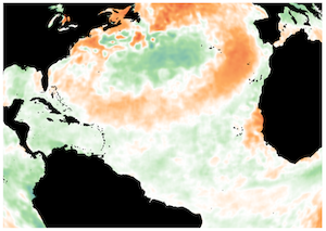
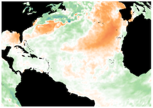
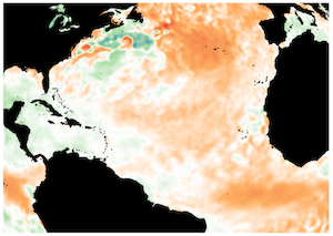
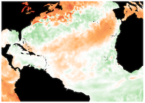
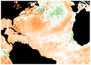
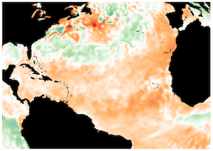
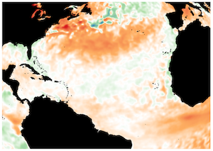
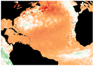
Sources: NOAA, Columbia University
“The ocean heat content is beating last year,” said Alex DaSilva, lead hurricane expert at commercial forecaster AccuWeather Inc. “We are still forecasting a hyper-active season. I am concerned that when we get into the heart of the season there could be many more storms, and more storms going on at the same time.”
Exceptionally warm waters aren’t just breeding hurricanes — they’re contributing to record temperatures on land, more evidence of how climate change is upending weather patterns the world over. Hot oceans have touched off a sweltering summer in the US, Asia and across parts of Europe, putting lives at risk, boosting insurance costs and laying bare the fragility of power grids and other infrastructure that wasn’t built for extreme heat.
Hurricane Beryl could prove to be an early omen of a catastrophic storm season.
Beryl, which formed in June, was the Atlantic’s earliest Category 5 hurricane on record, the most powerful on the five-step Saffir-Simpson scale. After devastating Grenada, it weakened over the Yucatan Peninsula but strengthened again in the warm waters of the Gulf of Mexico before slamming into Texas, leaving millions in the dark.
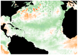
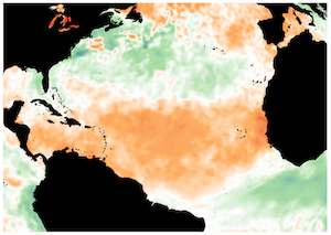
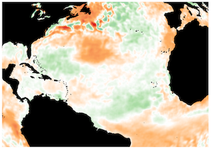
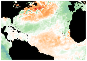
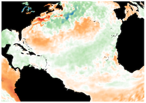
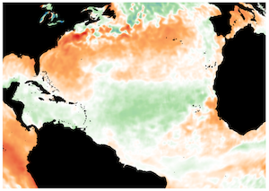
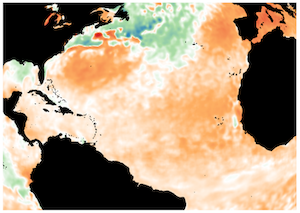
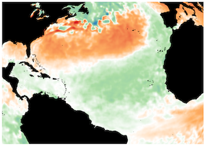
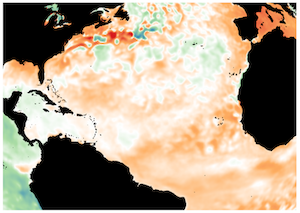
Beryl and Debby Signal More To Come As Peak Season Nears
Source: NOAA
“I was certainly surprised to see it get as strong as it did,” said Phil Klotzbach, lead author of Colorado State University’s seasonal hurricane forecast. “I’m quite worried what we’ll have in store” later in the summer.
Since Atlantic hurricane season typically doesn’t peak until September, that leaves plenty of time for more deadly storms like Beryl to emerge. In May, the National Oceanic and Atmospheric Administration predicted up to 25 named storms in this hurricane season, well above the average of 14.
The storm was born in an area of the Atlantic between the Caribbean and Africa that meteorologists call the main development region, which usually isn’t fired up until August and September. That section of ocean had its warmest June on record, with the average temperature simmering 3.19F above the 20th-century average.
Storms that form there, like Maria in 2017 and Andrew more than two decades earlier, can inflict billions of dollars of damage and untold misery.
Debby barreled into Florida as a Category 1 hurricane, knocking out power to hundreds of thousands of utility customers and grounding flights. It’s now unleashing heavy rain and flooding as it moves up the East Coast. Like Beryl, it formed unusually early: The second hurricane of the season usually doesn’t take shape until Aug. 26. And an area of unsettled weather in the eastern Atlantic signals that another storm may be close behind it.
The climate pattern known as La Niña, which lessens wind shear — change in wind speed and direction at varying altitudes that can rip apart storms — has been expected to take hold, magnifying the effects of warm waters. An above-normal west African monsoon season could also help hurricanes take shape, while a Saharan dust plume that’s blanketed the Atlantic this summer is dissipating, curbing a source of dry air that can help tame storms.
Hurricanes need two key ingredients to form: warm water and thunderstorms.
Hot oceans are expected to increase the frequency of a phenomenon known as rapid intensification, when a storm strengthens dramatically over a short period of time. Beryl first formed as a tropical depression on June 28, with winds of 35 mph. Warm water and low wind shear provided ideal conditions for the storm to grow. It took just 42 hours to intensify into a major hurricane.
Rapid intensification is particularly dangerous because it can take emergency managers by surprise and hinder timely evacuations. Last year, Otis barreled into Acapulco in Mexico, having intensified from a mere tropical storm to a Category 5 hurricane in fewer than 24 hours. National Hurricane Center forecaster Eric Blake called it a “nightmare scenario.”
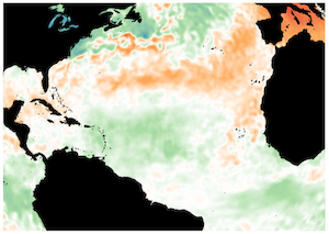
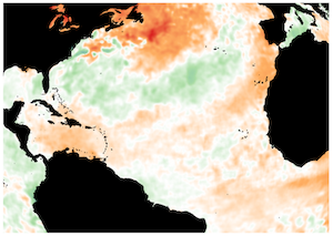
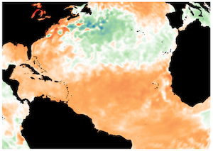
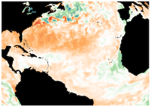
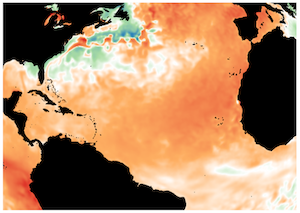
More Hot Water After Months of Record Breaking Temperatures
Sources: University of Maine, NOAA
Note: Data for 2024 through August 6.
From April 2023 through June of this year, the global monthly average sea-surface temperature was at a record seasonal high in data that go back to 1979. Those historical records haven’t just been narrowly surpassed — they’ve been obliterated.
The soaring temperatures haven’t come out of nowhere: The oceans have absorbed more than 90% of the excess heat trapped in the Earth’s system because of human-made global warming. The start of the El Niño phenomenon — La Niña’s opposing climate pattern — in 2023 also contributed to warmer waters.
Warmer oceans not only help generate hurricanes, but also exacerbate the rise in sea levels, restrict the supply of oxygen to marine life and contribute to what NOAA has labeled a “global coral bleaching event.” And hot oceans play a part in the melting of sea-ice, which threatens to weaken what’s known as the Atlantic Meridional Overturning Circulation, or AMOC — a system of currents that play a crucial role in regulating the planet’s climate.
“Buckle up for a summer of extreme events as these ocean heat waves continue to wreak havoc on the jet stream, fuel tropical storms, provide extra moisture for heavy rains, and disrupt marine ecosystems,” said Jennifer Francis, a climatologist with the Woodwell Climate Research Center.