Flood-Threat Assessment Finds Danger Goes Far Beyond U.S. Homes
If the floods don’t get you, lack of electricity or a swamped hospital might.
Nearly a quarter of U.S. critical infrastructure—utilities, airports, police stations and more—is at risk of being inundated by flooding, according to a new report by First Street Foundation, a Brooklyn nonprofit dedicated to making climate risk more visible to the public.

Includes airports, fire stations, hospitals, police stations, ports, power stations, and hazardous waste sites
Government buildings, historic buildings, houses of worship, museums, and schools
Critical
Infrastructure
25%
Roads
25%
Commercial
20%
Social
17%
Residential
14%

Includes airports, fire stations, hospitals, police stations, ports, power stations, and hazardous waste sites
Government buildings, historic buildings, houses of worship, museums, and schools
Critical
Infrastructure
25%
Roads
25%
Commercial
20%
Social
17%
Residential
14%

Includes airports, fire stations, hospitals, police stations, ports, power stations, and hazardous waste sites
Government buildings, historic buildings, houses of worship, museums, and schools
Critical
Infrastructure
25%
Roads
25%
Commercial
20%
Social
17%
Residential
14%
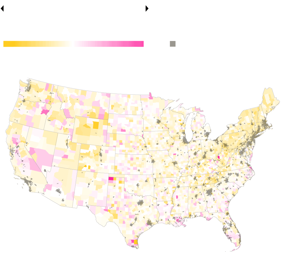
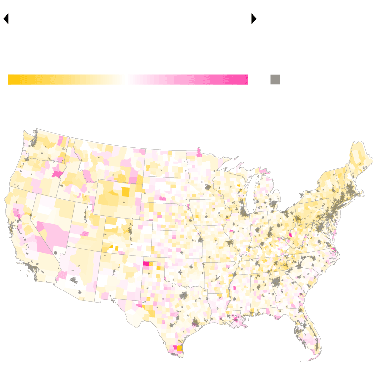
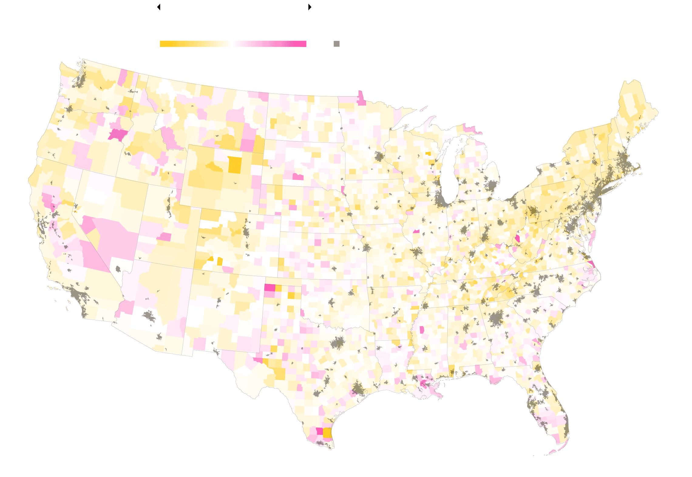
Roughly 14% of Americans’ properties face direct risk from major storms, but the study shows danger extends far from those property lines.
The authors say the report provides the first holistic understanding of flood risk beyond individual property level. In addition to critical infrastructure, the report assesses commercial buildings, millions of miles of roads and socially important institutions such as schools and museums.
“Even if your home is far from the risk of flooding or forest fires, you may not so easily escape the systemic impacts from vulnerable critical infrastructure that sometimes extends hundreds of miles,” said Jesse Keenan, a climate-change and real-estate expert at Tulane University in New Orleans.
The First Street report comes as Congress is debating whether to put trillions of dollars toward rebuilding aging infrastructure—and making it more resistant to extreme weather and flooding being exacerbated by climate change.
Critical Infrastructure At Risk

Higher share
infrastructure
Higher share
residences
+70pp.
0
+70
Urban areas
SACRAMENTO
MIAMI
Higher share
infrastructure
Higher share
residences
+70pp.
0
+70
Urban areas
SACRAMENTO
MIAMI
Higher share
infrastructure
Higher share
residences
+70pp.
0
+70
Urban areas
MIAMI
Higher share
infrastructure
Higher share
residences
+70pp.
0
+70
Urban areas
SACRAMENTO
MIAMI
Recent storms highlighted the vulnerability of the electric grid. In September, Hurricane Ida killed more than 40 people, at least 10 perishing in the heat amid power outages in Louisiana. A winter storm in Texas left more than 4 million people without electricity in February, and over 200 people died, the majority from cold.
“As we saw a few weeks ago following the devastation of Hurricane Ida, our nation’s infrastructure is not built to a standard that protects against the level of flood risk we face today, let alone how those risks will grow over the next 30 years,” said Matthew Eby, the First Street Foundation’s executive director. The report “will help inform where investment dollars should flow in order to best mitigate against that risk.”
The assessment is a massive task for a small group. First Street is a 30-person enterprise that funds itself through grants from climate philanthropies and data-sharing agreements with real-estate firms. It first achieved broad recognition with a 2020 report that made public flood risk of individual properties; previously such data was available only to insurers.
First Street uses models similar to those used by insurance companies to estimate annual flood risk in a wide variety of scenarios. It then combines the data with information from federal agencies on the specific levels of inundation that would make a building or road inoperable or inaccessible.
The most threatened areas are concentrated along the coast of the southeastern U.S. and in river-dense areas of Appalachia. In fact, the report found that 17 of the 20 most endangered communities are in Louisiana, Florida, Kentucky and West Virginia.
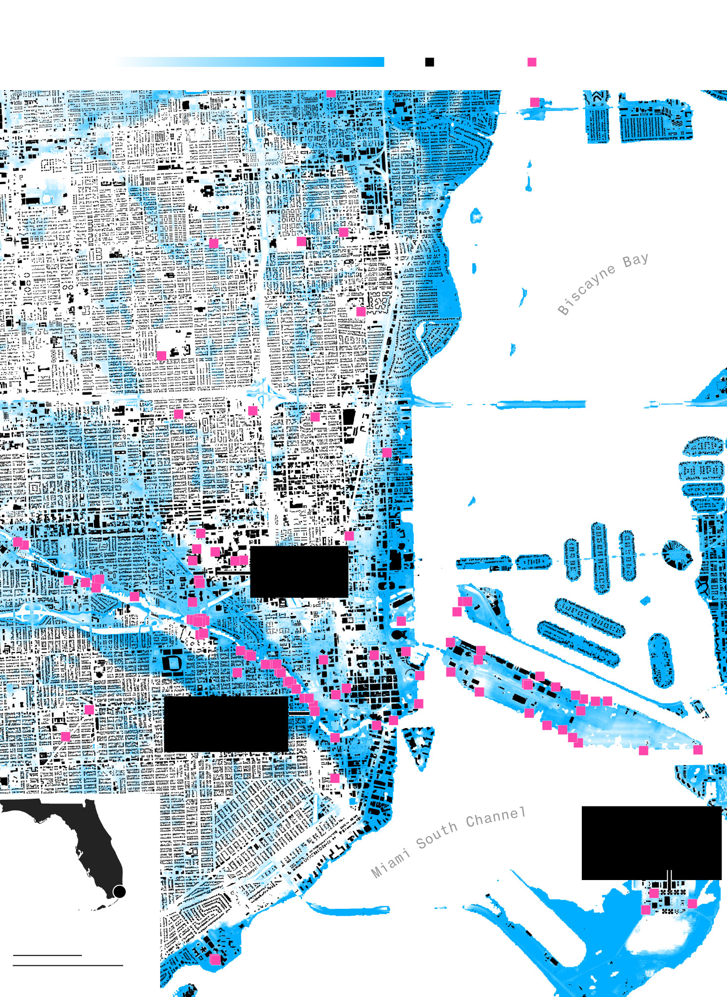
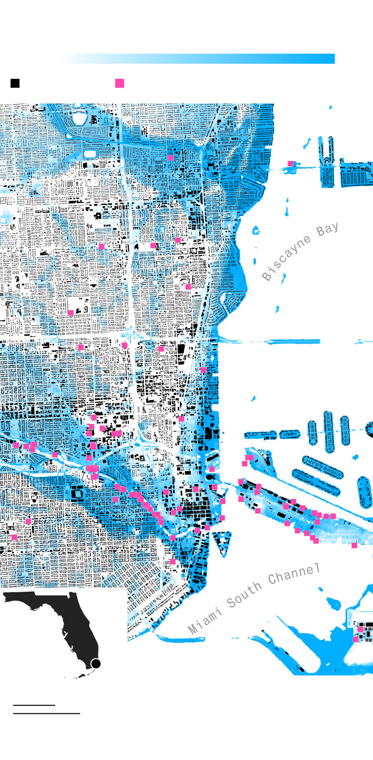
In Miami, for instance, roughly 50% of residences faced some flooding risk, whereas 83% of critical infrastructure faces at least a moderate risk.
Miami

Water depth
100 in.
0
Buildings
Critical infrastructure
ALLAPATTAH
EDGEWATER
MIAMI BEACH
Cluster of hospitals
DOWNTOWN MIAMI
LITTLE HAVANA
Ports along the Miami River
Central District wastewater treatment plant
Miami
VIRGINIA KEY
1 mi
1 km
Water depth
100 in.
0
Buildings
Critical infrastructure
EDGEWATER
MIAMI BEACH
Cluster of hospitals
LITTLE HAVANA
DOWNTOWN MIAMI
Ports along the Miami River
Central District wastewater treatment plant
Miami
VIRGINIA KEY
1 mi
1 km
Water depth
100 in.
0
Buildings
Critical infrastructure
LITTLE HAVANA
DOWNTOWN MIAMI
VIRGINIA KEY
Miami
1 mi
1 km
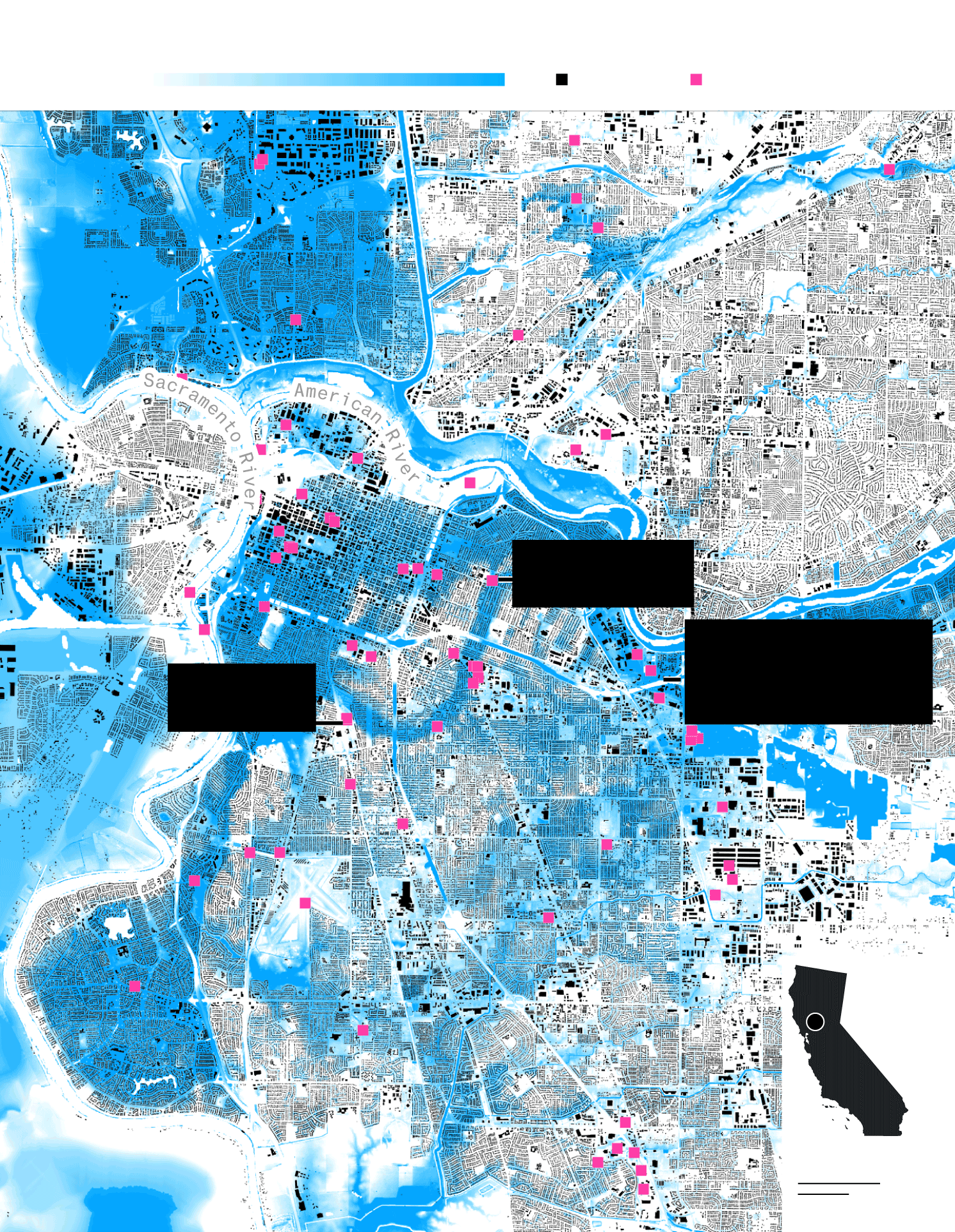
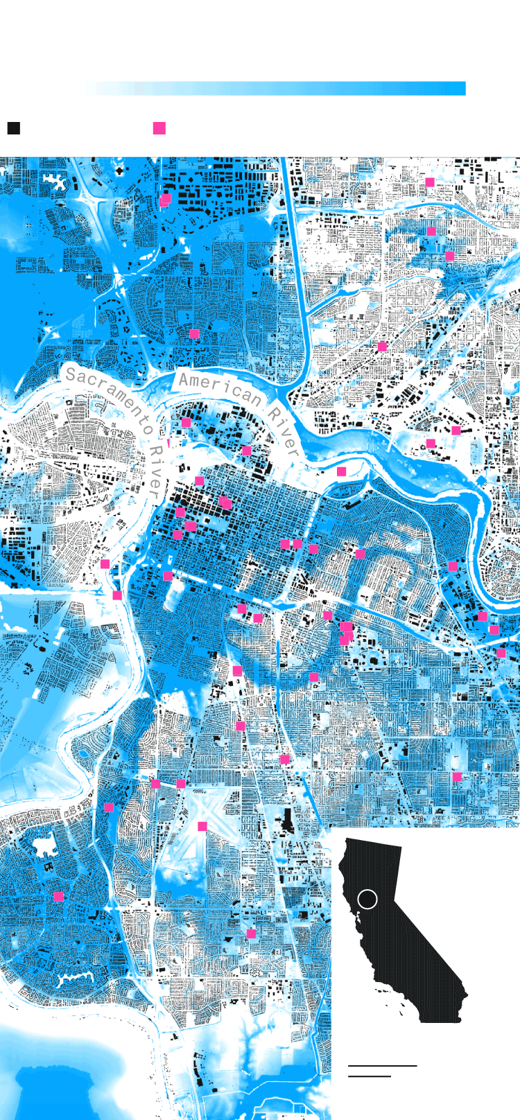
Still, the maps show that flood risk isn’t limited to predictable places. In drought-ridden California, the river cities of Sacramento and Stockton were among First Street’s top 10 riskiest municipalities. Each had more than 65% of critical infrastructure in danger.
The report makes clear that there are few parts of the U.S. that will escape global warming unscathed.
Sacramento, California

Water depth
100 in.
0
Buildings
Critical infrastructure
NORTH SACRAMENTO
WEST
SACRAMENTO
EAST
SACRAMENTO
Cluster of police and fire stations
Mercy General Hospital
Water treatment and power stations near the American River
Hazardous waste site
PARKWAY
Sacramento
1 mi
1 km
Water depth
100 in.
0
Buildings
Critical infrastructure
NORTH SACRAMENTO
WEST
SACRAMENTO
Mercy General Hospital
Water treatment and power stations near the American River
Hazardous waste site
EAST
SACRAMENTO
Sacramento
PARKWAY
1 mi
1 km
Water depth
100 in.
0
Buildings
Critical infrastructure
NORTH SACRAMENTO
WEST
SACRAMENTO
EAST
SACRAMENTO
Sacramento
PARKWAY
1 mi
1 km