

Carbon monoxide concentration from Dec. 29–31 in parts per billion by volume, Source: NASA
Australia Fire Maps: Where the Devastating Wildfires Are Burning
Australia is facing a nationwide crisis as record-breaking temperatures and months of severe drought have fueled an unprecedented number of fires burning in five states. More than 15.6 million acres (6.3 million hectares)—about the size of West Virginia and three times the size of Wales—have been destroyed this fire season. As of Tuesday, the death toll from the fires had climbed to 24, with dozens more unaccounted for.
In Victoria, where about 200 homes were destroyed, emergency services had 39 public warnings in place early Tuesday, and detailed 77 specific fire incidents in the state. Fires forced vacationing tourists and residents on the coast in the state of Victoria to take cover on beaches. In the coastal town of Mallacoota, navy ships rescued about 1,000 people on Friday with another 200 due to be rescued later this week. Showers are giving firefighters some relief but hot conditions are forecast to return.
Fires continue to burn on South Australia’s Kangaroo Island, where two people died in a blaze. The fire has burned 155,000 hectares—about one third of the island’s entire area, devastating the national park and farmland.
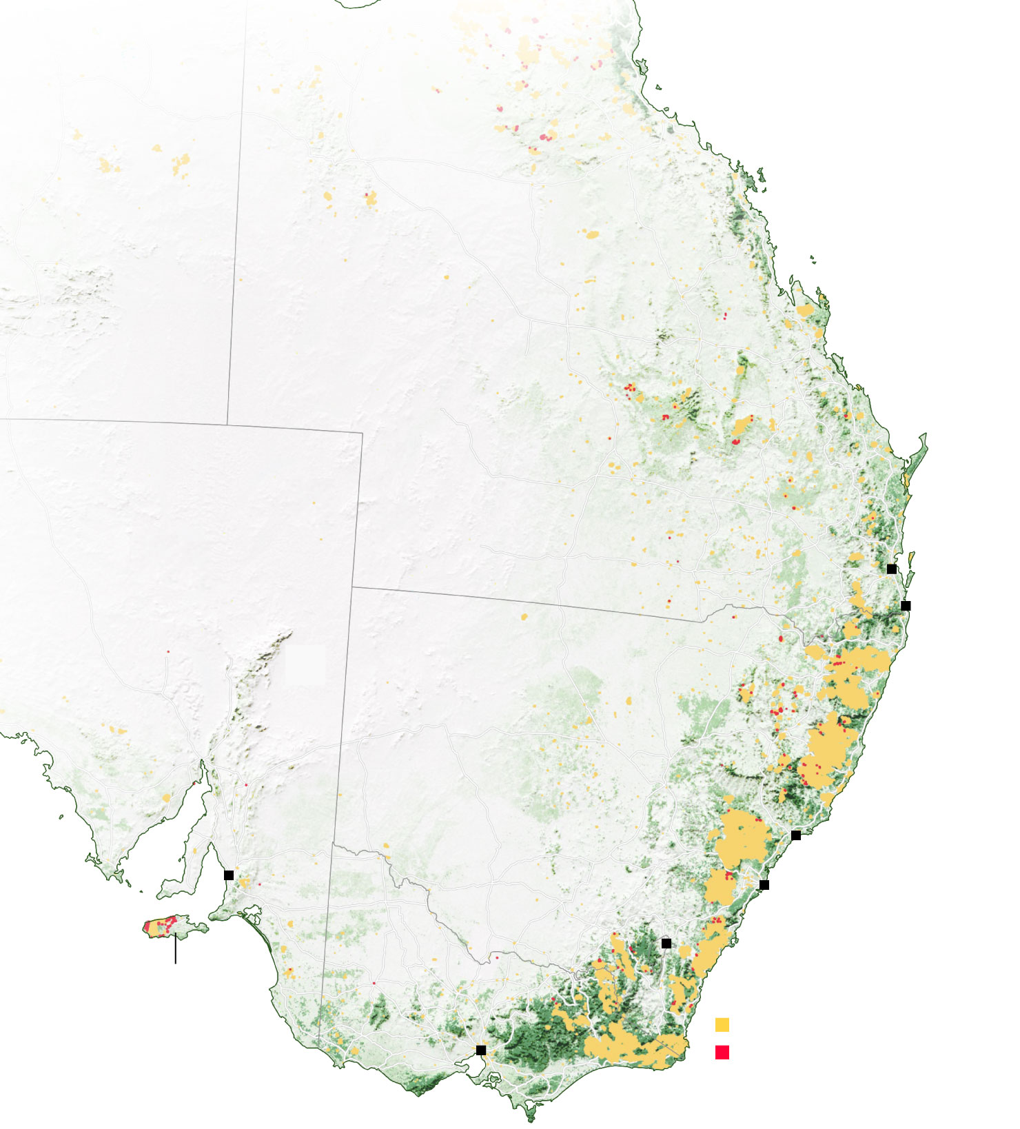
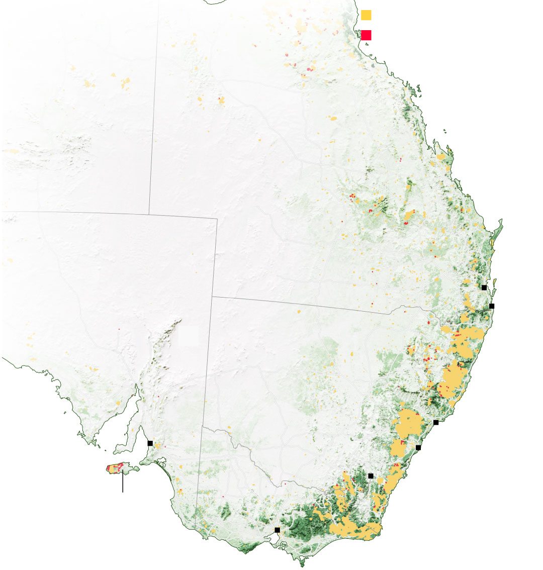
Fire hotspots from Oct. 1 to Jan. 7
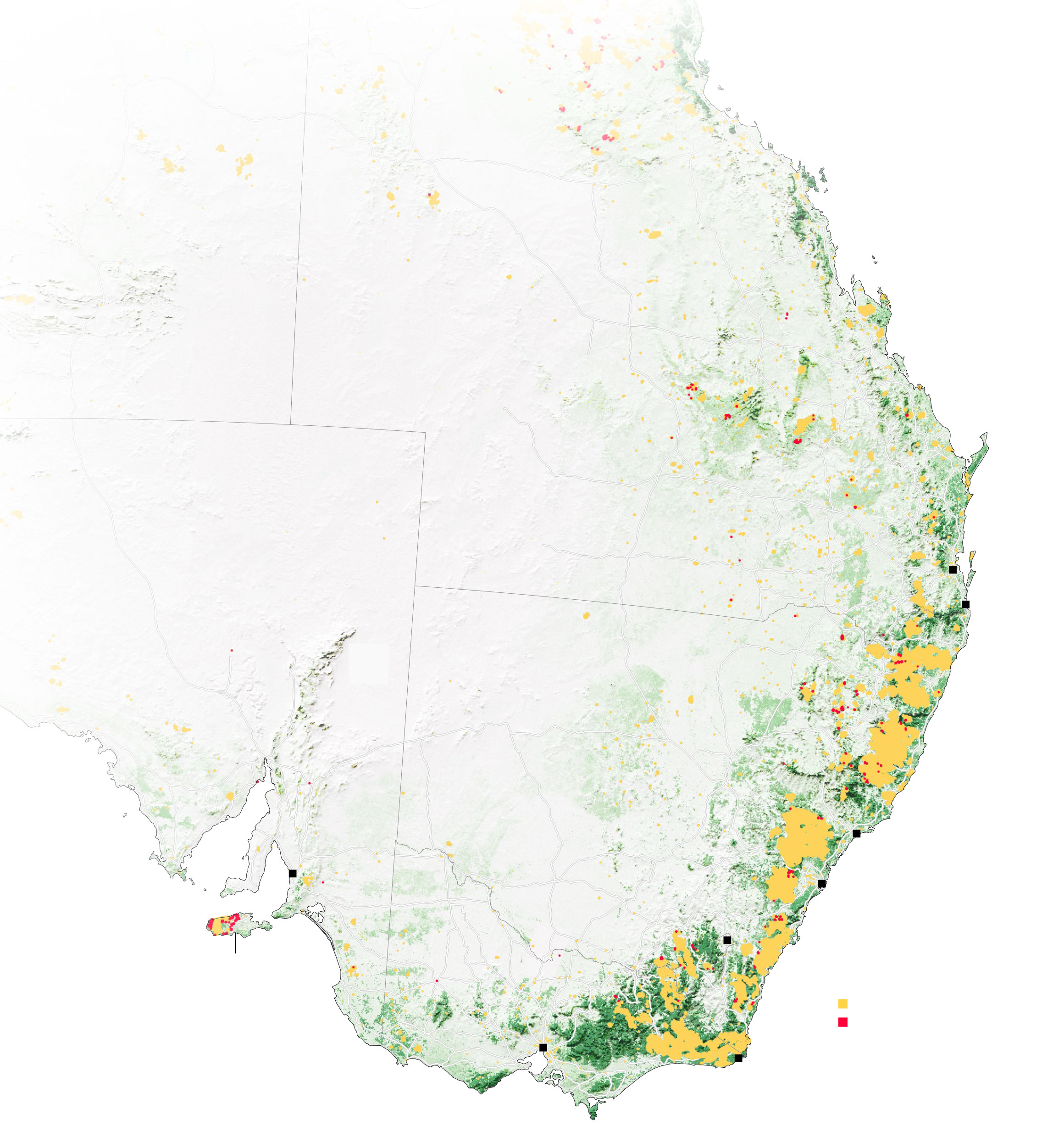
Northern Territory
Queensland
Australia
Brisbane
South Australia
Gold Coast
New South Wales
Newcastle
Adelaide
Sydney
Canberra
victoria
Kangaroo Island
Fires Oct. 1, 2019 to Jan. 6
Active fires as of Jan. 7
Melbourne
Mallacoota
Northern
Territory
Queensland
Australia
Brisbane
South Australia
Gold Coast
New South Wales
Newcastle
Adelaide
Sydney
Canberra
Kangaroo Island
Fires Oct. 1, 2019 - Jan. 6
Melbourne
Active fires as of Jan. 7
Fires Oct. 1, 2019 - Jan. 6
Active fires as of Jan. 7
Northern
Territory
Queensland
Australia
South Australia
Brisbane
Gold
Coast
New South Wales
Newcastle
Adelaide
Sydney
Canberra
Kangaroo Island
Melbourne

Queensland
Australia
Brisbane
New South Wales
Sydney
Canberra
Melbourne
Fires Oct. 1, 2019 - Jan. 6
Active fires as of Jan. 7
South
Australia
New South
Wales
Adelaide
Kangaroo Island
Melbourne
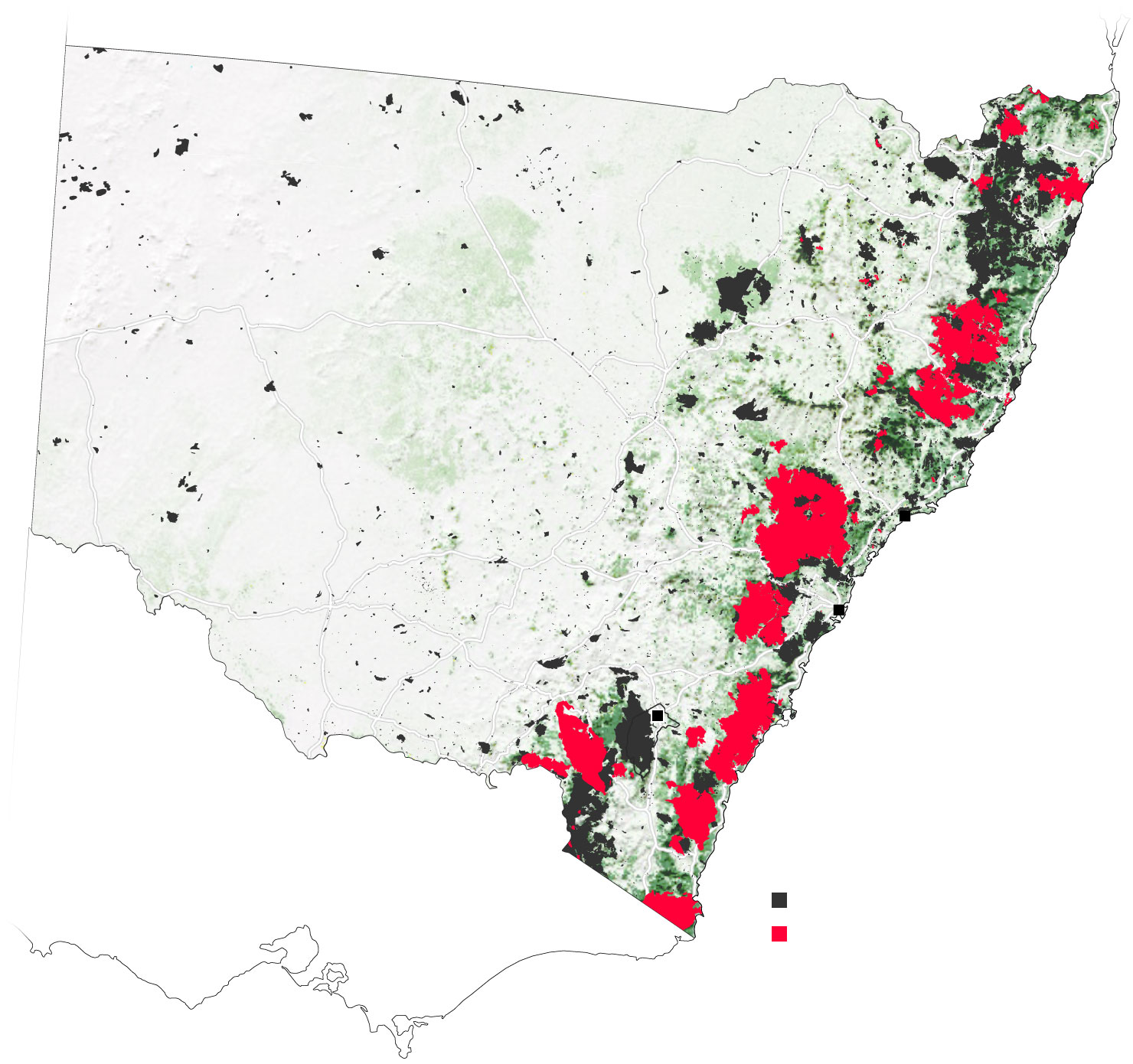
A state of emergency lasting seven days was called on Friday in New South Wales, which has been hardest hit with nearly 9 million acres destroyed. About 130 fires were burning across the state at the start of last weekend, and more than 1,588 homes have been destroyed. Evacuations were ordered for a 350 kilometer (217 mile) stretch of coastline in the southern part of the state.
New South Wales sees worst fire season in years
QUEENSLAND
NEW SOUTH WALES
Newcastle
Sydney
Canberra
VICTORIA
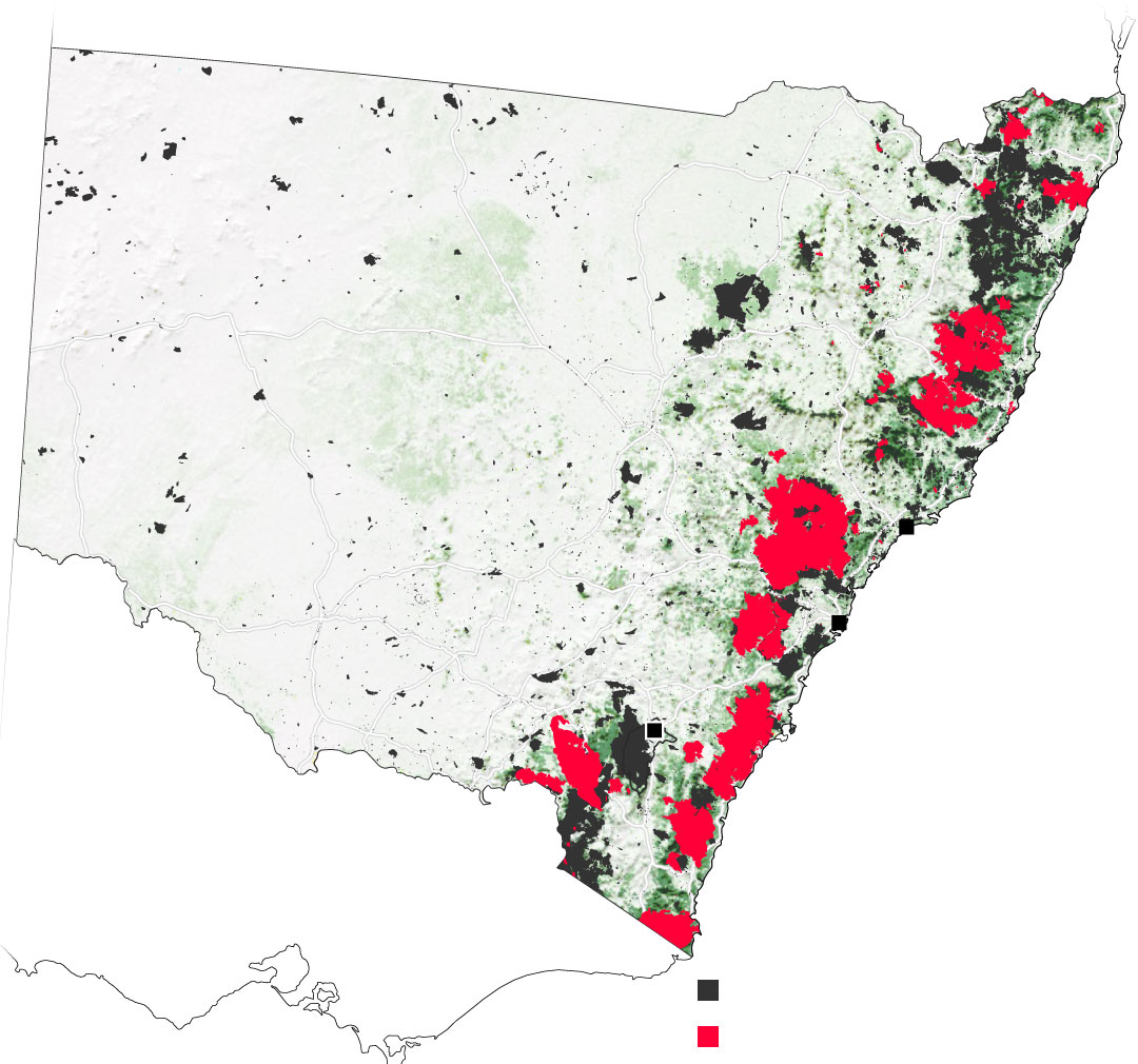
Fire history, 2001-2019
Active fire alerts Jan. 7, 2020
QUEENSLAND
NEW SOUTH WALES
Newcastle
Sydney
Canberra
VICTORIA
Fire history, 2001-2019
Active fire alerts Jan. 7, 2020

Fire history, 2001-2019
Active fire alerts Jan. 7, 2020
QUEENSLAND
NEW SOUTH
WALES
Newcastle
Sydney
Canberra
VICTORIA
High winds and hot, dry conditions—it was the hottest and driest year on record in 2019—have made some of the blazes nearly impossible to contain. Winds can help fires grow so large that they’re capable of spawning fire tornadoes that spew embers dozens of kilometers away—sparking new fires.
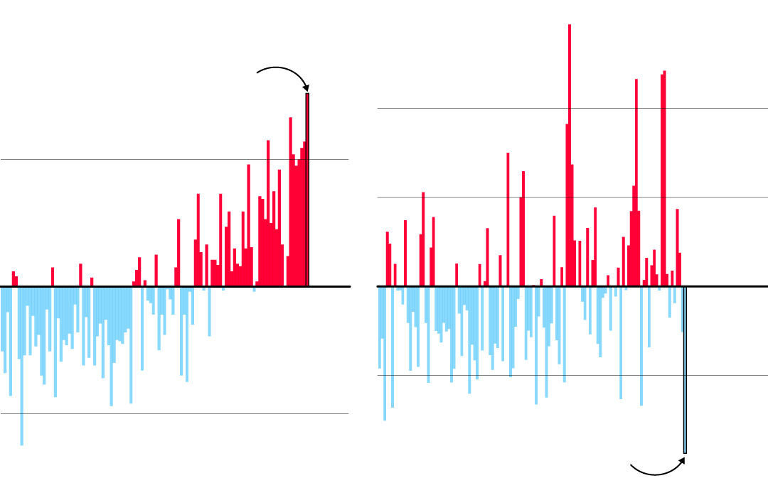
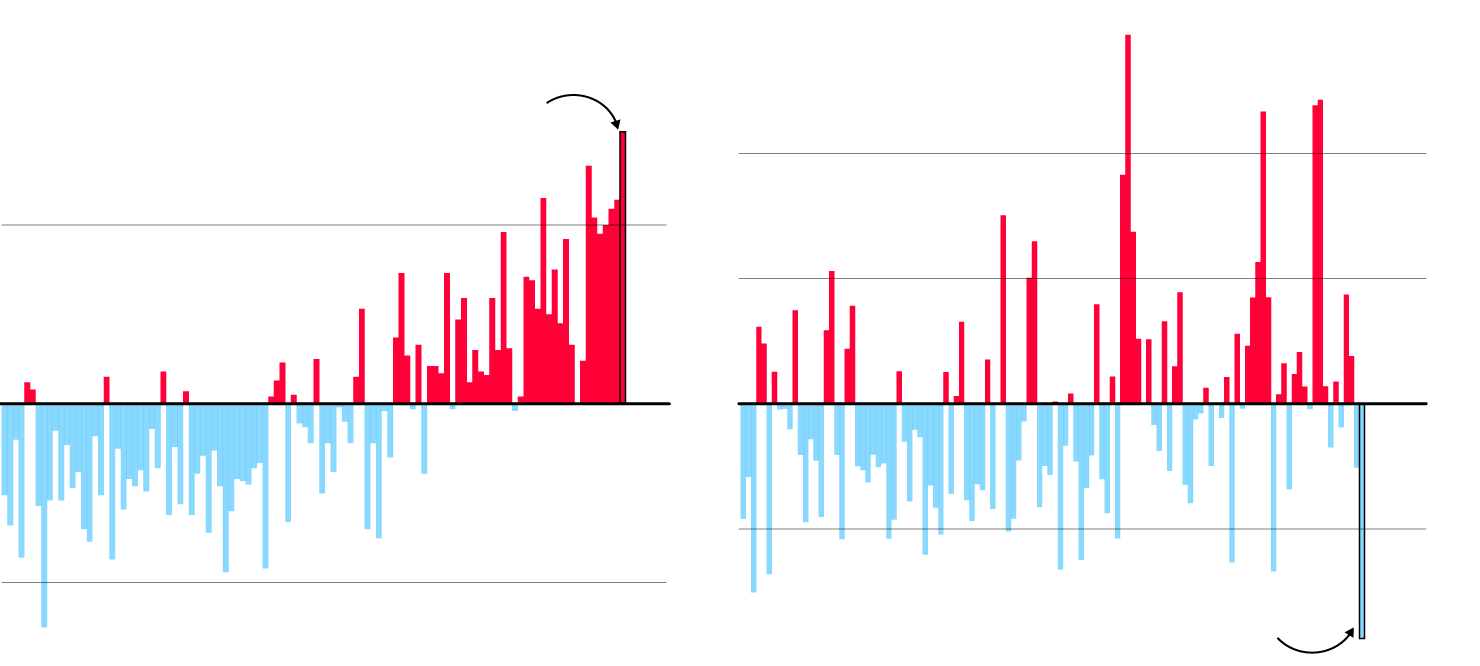
Hottest and driest

Annual mean temperature anomaly,
1910–2019
2019 is the hottest year
ever recorded in Australia ...
1°C
0
-1
Annual rainfall anomaly,
1900–2019
200mm
100
0
-100
... coincidentally it is
also the driest year
Annual mean temperature
anomaly, 1910–2019
Annual rainfall anomaly,
1900–2019
2019 is the hottest year
ever recorded in Australia ...
200mm
1°C
100
0
0
-100
-1
... coincidentally it is
also the driest year
Annual mean temperature anomaly,
1910–2019
Annual rainfall anomaly,
1900–2019
2019 is the hottest year
ever recorded in Australia ...
200mm
1°C
100
0
0
-100
... coincidentally it is
also the driest year
-1
Many of the blazes have spread through rural forests and grazing land. About half a billion native animals may have been killed in the blazes in New South Wales state alone, according to researchers at the University of Sydney, while tens of thousands of livestock may have been lost in Victoria, the Australian Broadcasting Corporation cited the state agriculture minister as saying.
Even areas removed from the fires are feeling their impact. Smoke from the blazes has drifted as far as New Zealand, 2,000 kilometers (1,200 miles) away. In Sydney, the air quality measured 12 times the “hazardous” level earlier in December.

Neville Nicholls, professor emeritus at Monash University’s School of Earth, Atmosphere and Environment, said the peak time for heatwaves in southern Australia has not yet arrived.