Louisiana Unveils Ambitious Plan to Help People Get Out of the Way of Climate Change
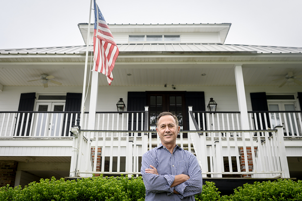
Gerard Braud has no plans to leave his handsome Creole-style house with its 15-foot-high front porch on the north shore of Lake Pontchartrain, a short drive from New Orleans. “Peacefulness and tranquility” is how he explains the appeal of living here.
Except that thanks in part to climate change, the lake keeps hopping the short seawall in front of Braud’s house and taking over his neatly manicured lawn—not just during hurricanes, but also when the tide is high and the winds are strong. His flood insurance premiums have almost doubled to $5,000 a year, making him wonder how difficult it would be to sell even if he wanted to.
In flood-prone areas across southern Louisiana, residents such as Braud risk running out of choices: living in homes that are hard to leave but put them in harm’s way. In response, the state on Wednesday issued a sweeping blueprint—the first of its kind in the U.S.—for managing the ongoing population movement away from its coastal areas, and preparing inland communities to receive an infusion of people.
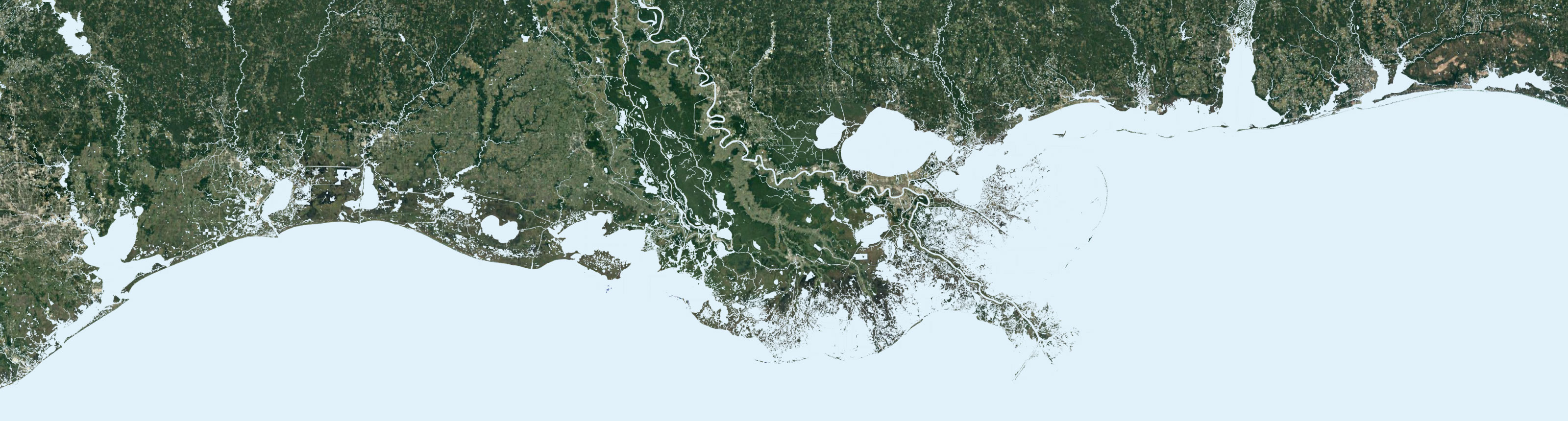
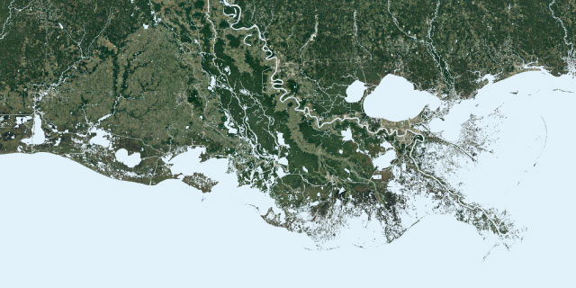
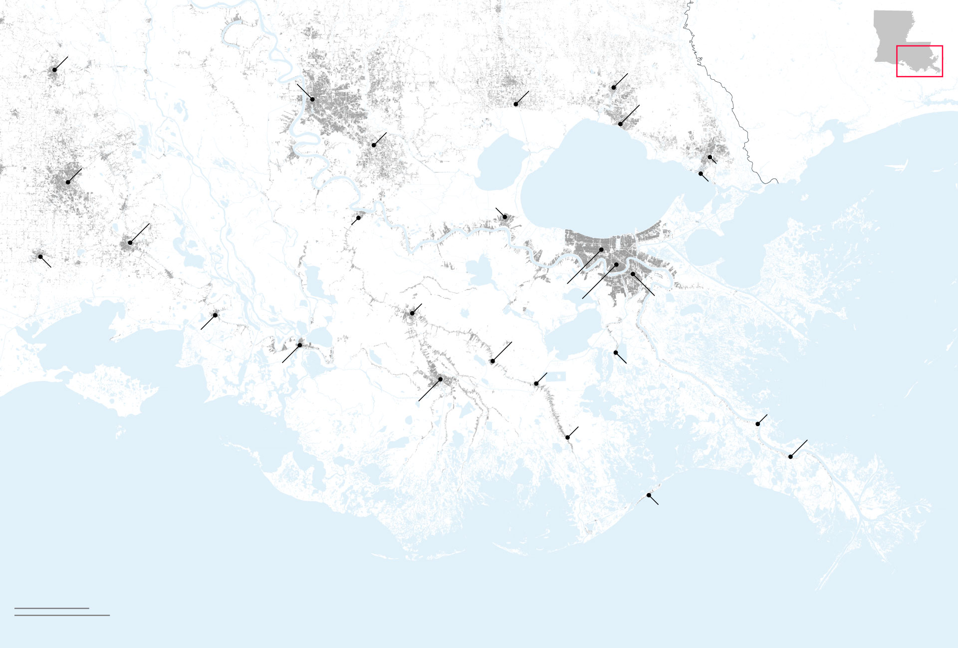
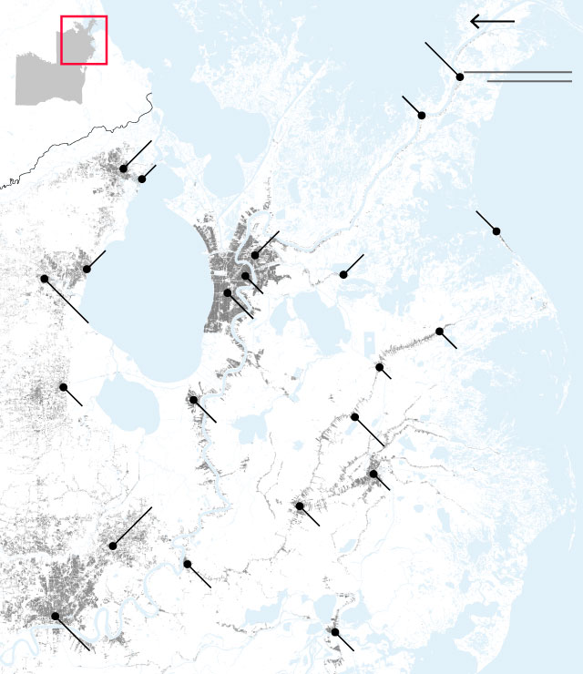
A narrowing footprint: Building patterns in southern Louisiana

Louisiana
Mississippi
LA
Opelousas
Covington
Baton Rouge
Hammond
Mandeville
Prairieville
Lafayette
Slidell
Lake
Pontchartrain
Eden Isle
LaPlace
Lake
Borgne
New Iberia
Donaldsonville
Abbeville
Metairie
Thibodaux
Gretna
New Orleans
Chandeleur
Sound
Franklin
Lockport
Morgan City
Larose
Lafitte
Houma
Empire
Golden Meadow
Buras-Triumph
Grand Isle
Gulf of
Mexico
20 miles
50 km
Louisiana
Mississippi
LA
Opelousas
Covington
Hammond
Baton Rouge
Mandeville
Prairieville
Lafayette
Lake
Pontchartrain
Slidell
Eden Isle
LaPlace
Lake
Borgne
New Iberia
Donaldsonville
Abbeville
Metairie
New Orleans
Thibodaux
Gretna
Chandeleur
Sound
Franklin
Lockport
Morgan City
Larose
Lafitte
Houma
Empire
Golden Meadow
Buras-Triumph
Grand Isle
Gulf of
Mexico
20 miles
50 km
North
20 miles
Buras-Triumph
LA
50 km
Empire
Slidell
Eden Isle
MS
LA
Grand Isle
Gretna
Mandeville
Covington
Lafitte
Lake
Pontchartrain
New Orleans
Metairie
Golden Meadow
Larose
Hammond
LaPlace
Lockport
Prairieville
Houma
Thibodaux
Donaldsonville
Gulf of
Mexico
Morgan City
Baton Rouge
Franklin
North
Buras-Triumph
20 miles
LA
Empire
50 km
Slidell
MS
Eden Isle
Gulf of
Mexico
LA
Grand Isle
Gretna
Mandeville
Lafitte
Lake
Pontchartrain
New Orleans
Metairie
Covington
Golden Meadow
Larose
Hammond
LaPlace
Lockport
Houma
Prairieville
Thibodaux
Donaldsonville
Morgan City
Baton Rouge
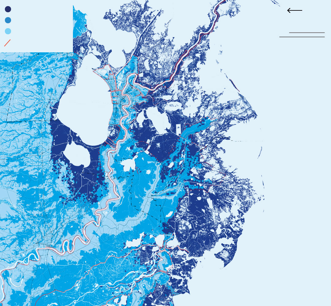
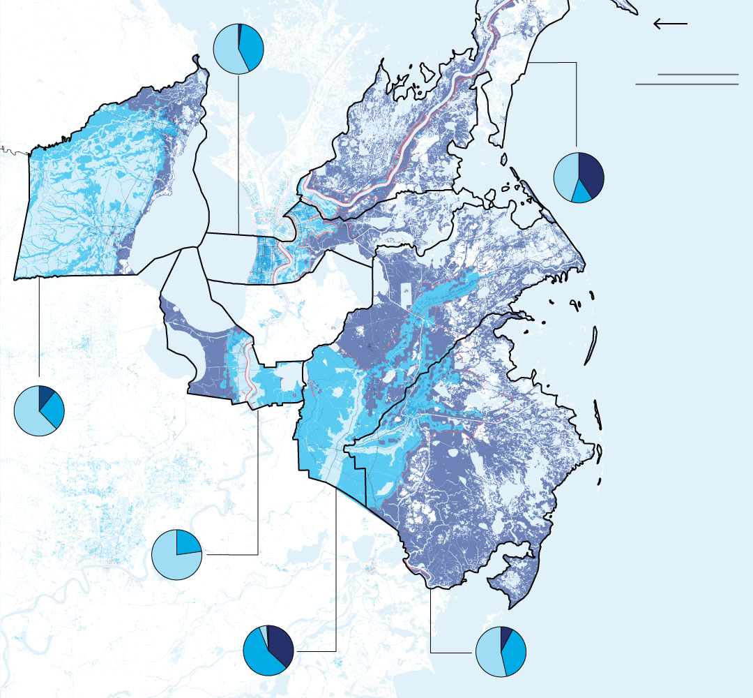
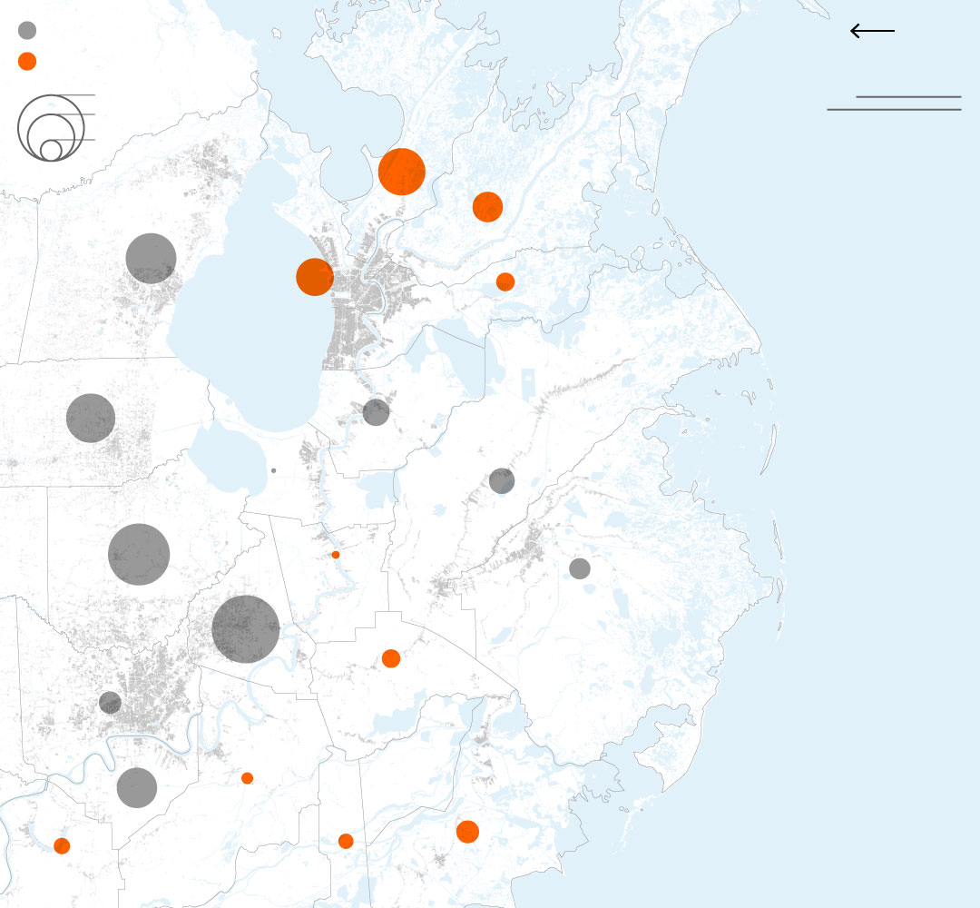
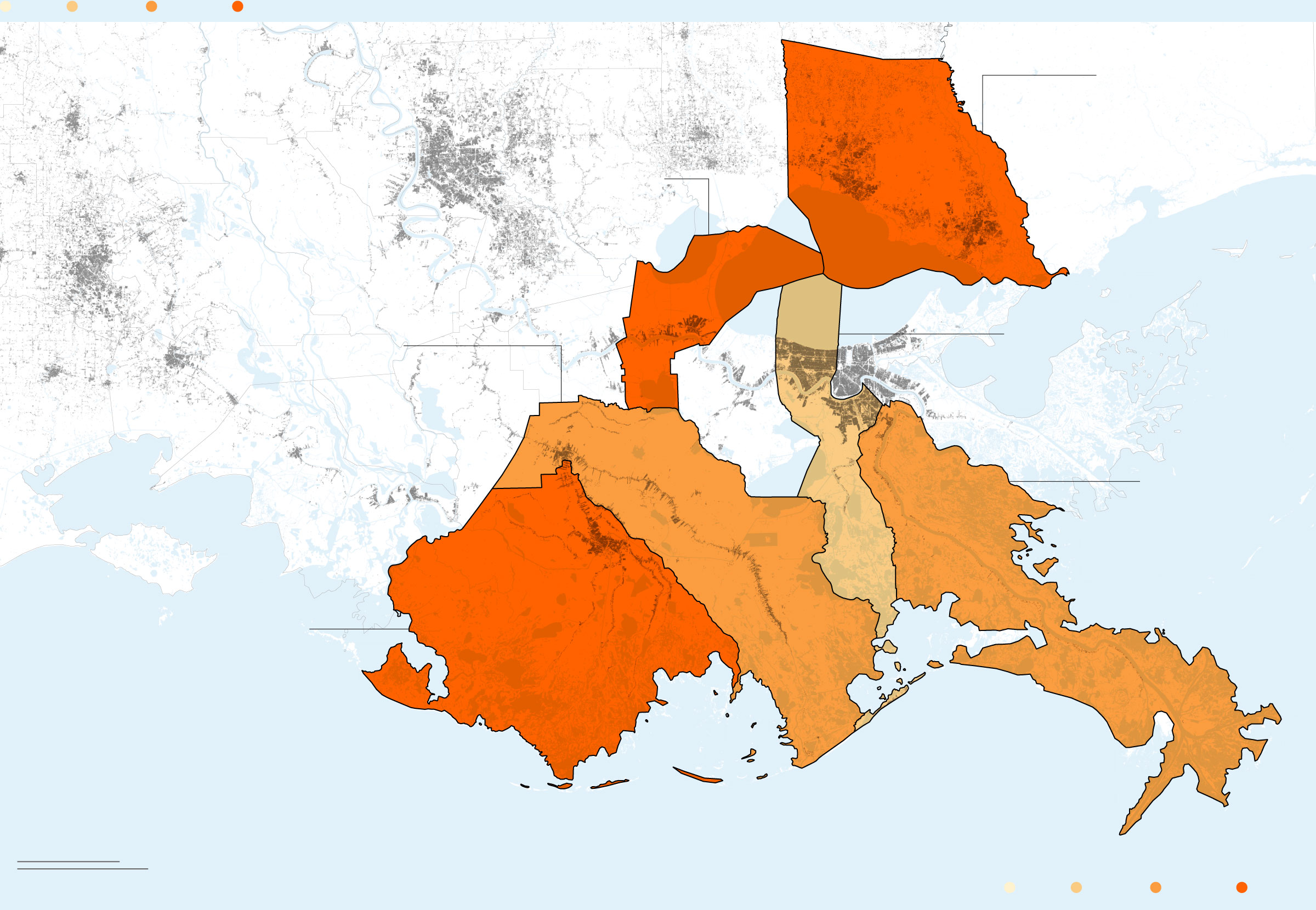
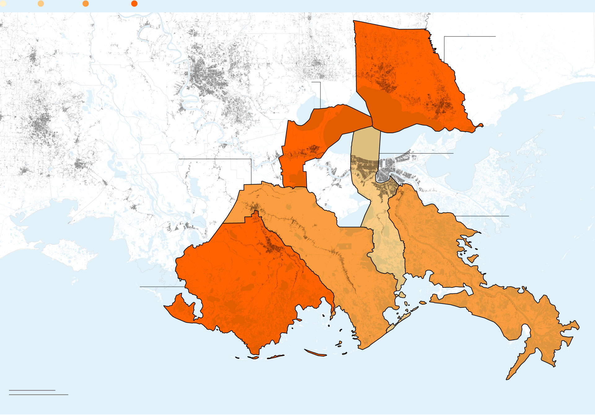
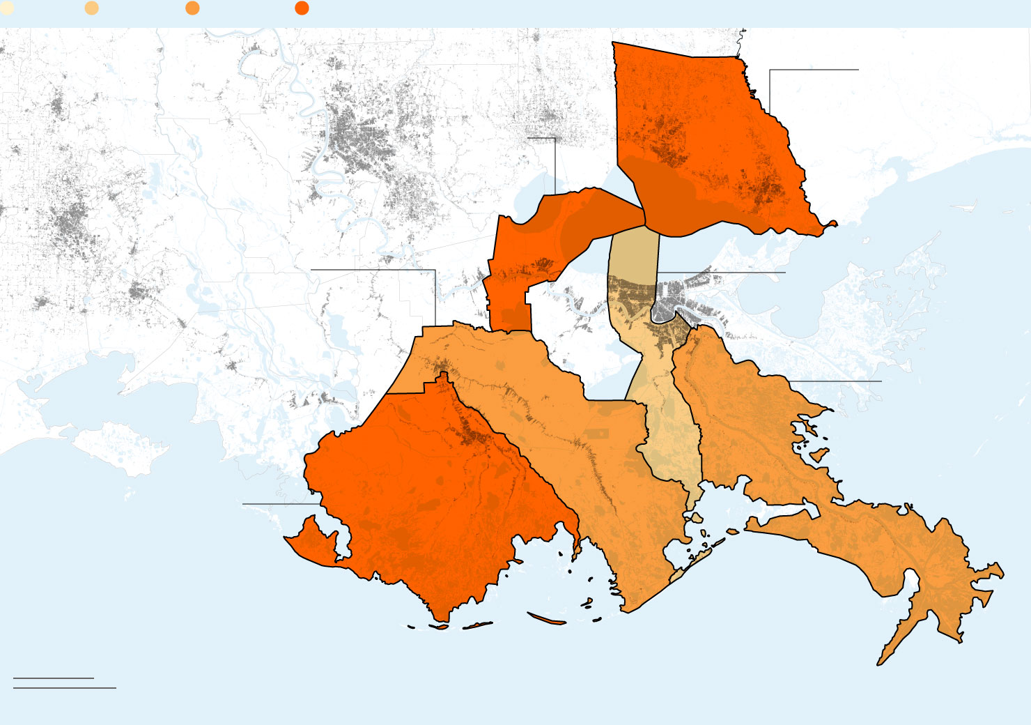
Louisiana has divided its coast into three categories of flood risk
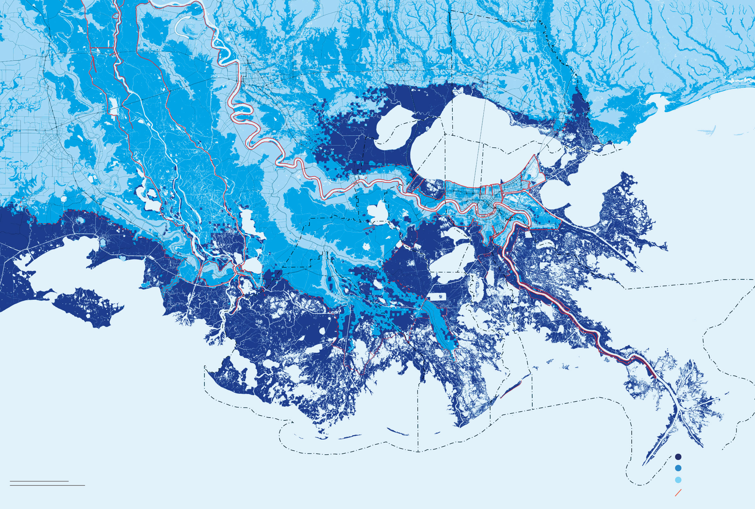
High risk
Moderate risk
20 miles
Low risk
50 km
Federal levees
20 miles
High risk
Moderate risk
50 km
Low risk
Federal levees
High risk
20 miles
Moderate risk
Low risk
Federal levees
50 km
High risk
North
Moderate risk
20 miles
Low risk
Federal levees
50 km

High risk
North
Moderate risk
20 miles
Low risk
Federal levees
50 km
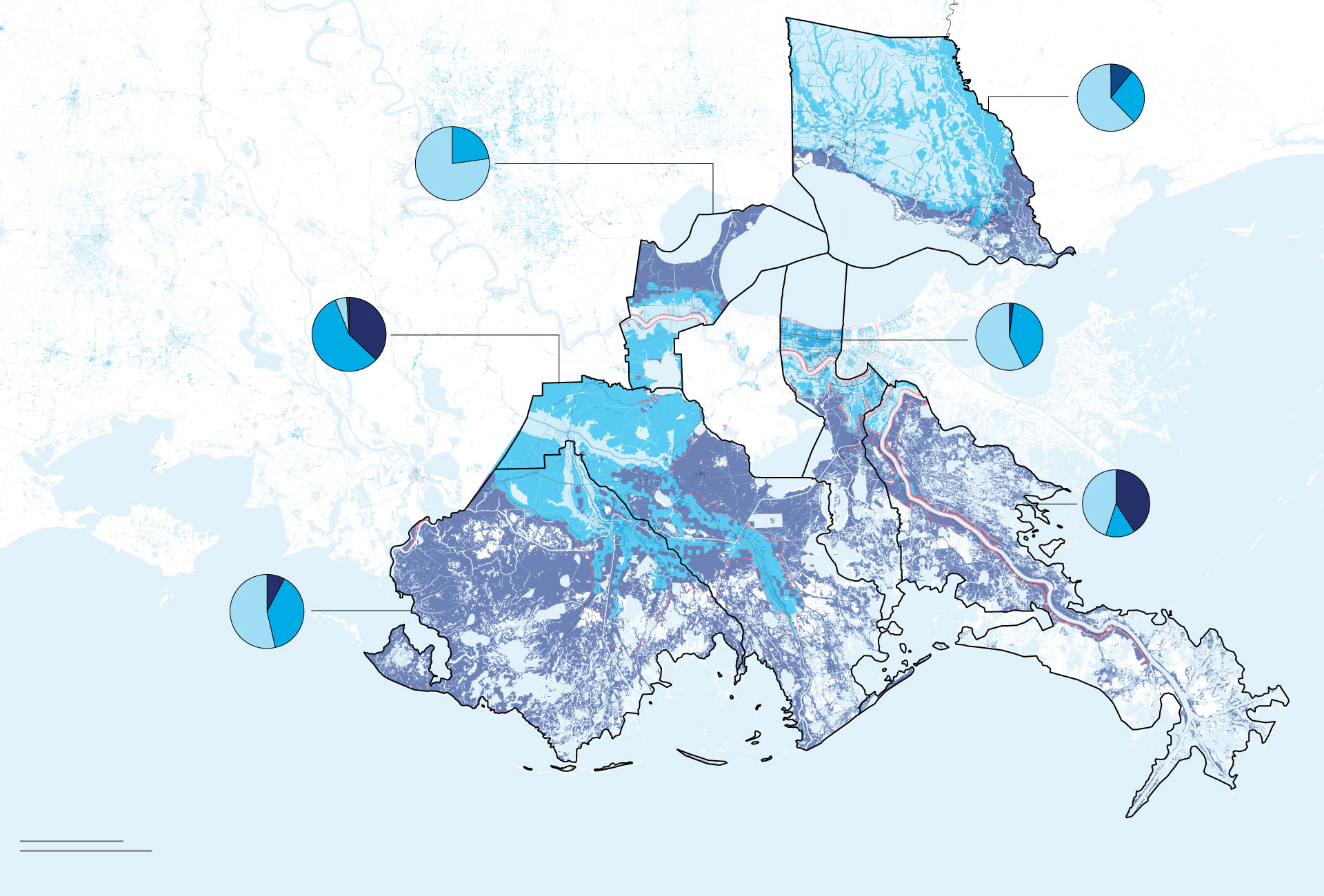
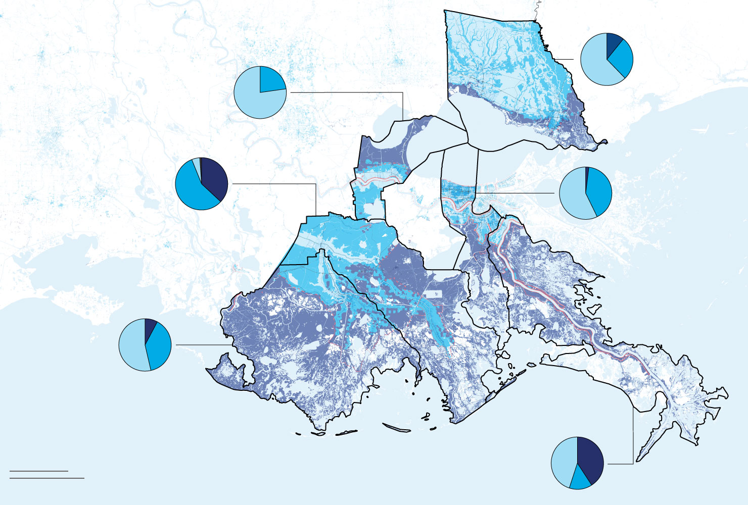
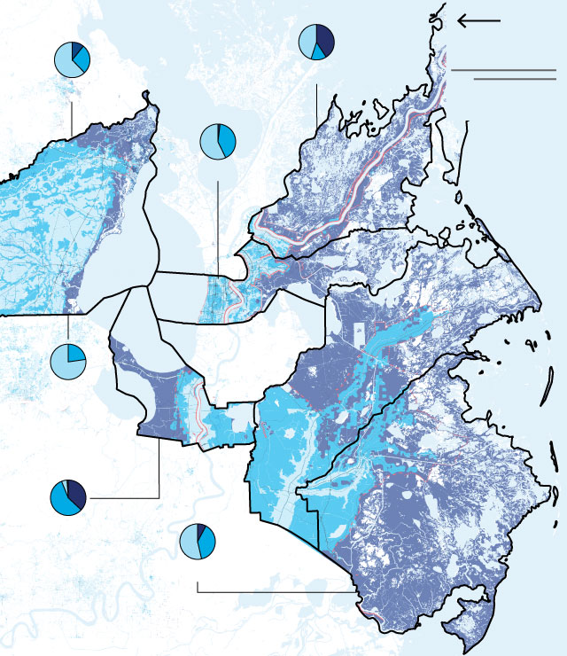
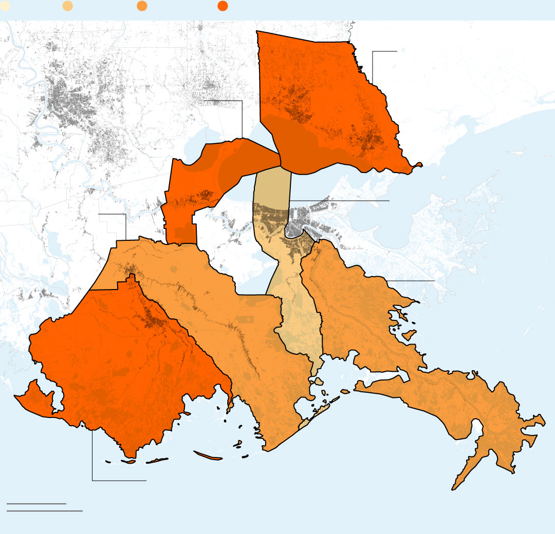
Share of population living in each risk zone by parish

Louisiana
Mississippi
ST. TAMMANY
11% High risk
27% Moderate risk
62% Low risk
ST. JOHN
THE BAPTIST
0% High risk
23% Moderate risk
77% Low risk
LAFOURCHE
37% High risk
57% Moderate risk
5% Low risk
JEFFERSON
2% High risk
41% Moderate risk
57% Low risk
Chandeleur
Sound
PLAQUEMINES
41% High risk
14% Moderate risk
45% Low risk
TERREBONNE
8% High risk
39% Moderate risk
54% Low risk
Gulf of
Mexico
20 miles
50 km
Louisiana
Mississippi
ST. TAMMANY
11% High risk
27% Moderate risk
62% Low risk
ST. JOHN
THE BAPTIST
0% High risk
23% Moderate risk
77% Low risk
LAFOURCHE
37% High risk
57% Moderate risk
5% Low risk
JEFFERSON
2% High risk
41% Moderate risk
57% Low risk
Chandeleur
Sound
TERREBONNE
8% High risk
39% Moderate risk
54% Low risk
Gulf of
Mexico
PLAQUEMINES
41% High risk
14% Moderate risk
45% Low risk
20 miles
50 km
JEFFERSON
2% High risk
41% Moderate risk
57% Low risk
North
20 miles
50 km
MS
PLAQUEMINES
41% High risk
14% Moderate risk
45% Low risk
LA
ST. TAMMANY
11% High risk
27% Moderate risk
62% Low risk
ST. JOHN
THE BAPTIST
0% High risk
23% Moderate risk
77% Low risk
Gulf of
Mexico
LAFOURCHE
37% High risk
57% Moderate risk
5% Low risk
TERREBONNE
8% High risk
39% Moderate risk
54% Low risk
North
20 miles
PLAQUEMINES
ST. TAMMANY
50 km
MS
Gulf of
Mexico
JEFFERSON
LA
ST. JOHN
THE BAPTIST
LAFOURCHE
TERREBONNE
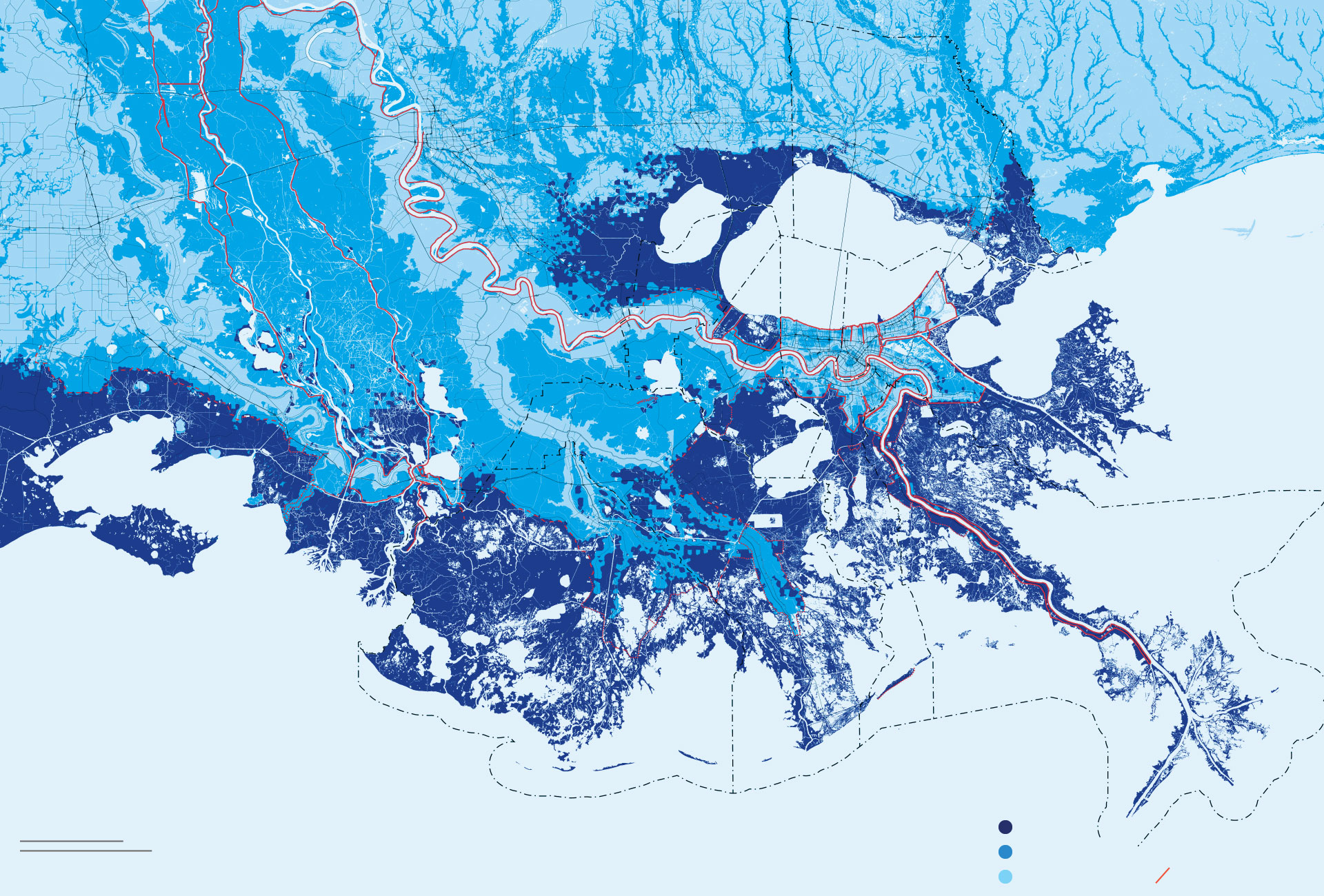
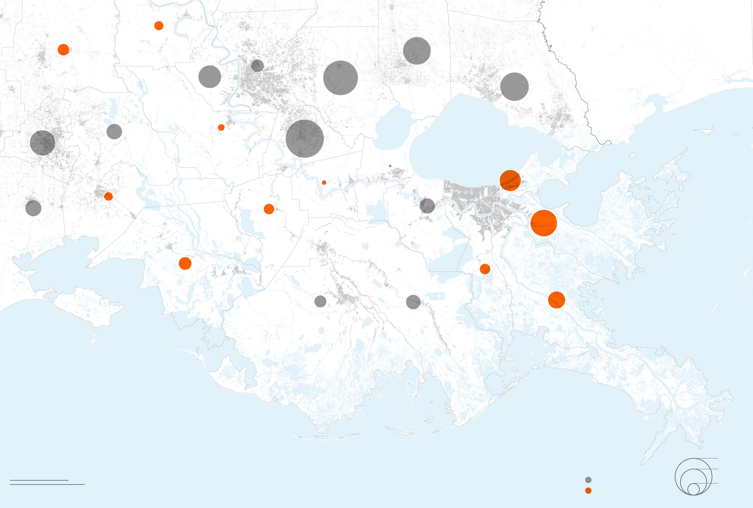
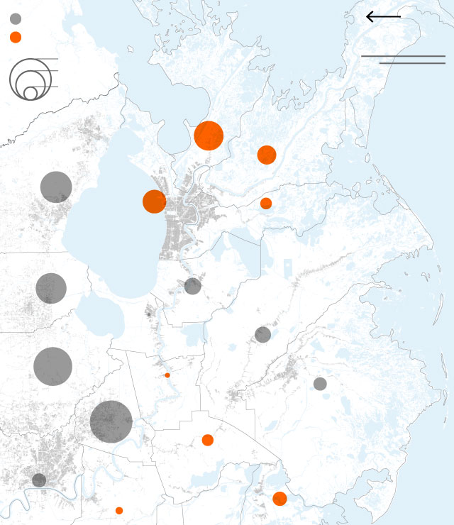
Population change by parish, 2000-2018
Louisiana
Mississippi
POINTE
COUPEE
E. BATON
ROUGE
TANGIPAHOA
ST. LANDRY
W. BATON
ROUGE
LIVINGSTON
ST. TAMMANY
ST. MARTIN
IBERVILLE
Lake
Pontchartrain
ASCENSION
LAFAYETTE
ST. JOHN
THE BAPTIST
Lake
Borgne
ORLEANS
ST. JAMES
IBERIA
VERMILION
SAINT
CHARLES
ASSUMPTION
ST. BERNARD
Chandeleur
Sound
ST. MARY
JEFFERSON
LAFOURCHE
TERREBONNE
PLAQUEMINES
Gulf of
Mexico
100%
50
20 miles
Gained population
10
Lost population
50 km

Louisiana
Mississippi
POINTE
COUPEE
E. BATON
ROUGE
TANGIPAHOA
ST. LANDRY
W. BATON
ROUGE
LIVINGSTON
ST. TAMMANY
ST. MARTIN
Lake
Pontchartrain
IBERVILLE
ASCENSION
LAFAYETTE
ST. JOHN
THE BAPTIST
Lake
Borgne
ORLEANS
ST. JAMES
IBERIA
VERMILION
SAINT
CHARLES
ASSUMPTION
ST. BERNARD
Chandeleur
Sound
JEFFERSON
ST. MARY
LAFOURCHE
PLAQUEMINES
TERREBONNE
Gulf of
Mexico
Population change
by parish
100%
20 miles
50
Gained population
10
Lost population
50 km
Louisiana
Mississippi
POINTE
COUPEE
E. BATON
ROUGE
TANGIPAHOA
ST. LANDRY
W. BATON
ROUGE
LIVINGSTON
ST. TAMMANY
ST. MARTIN
Lake
Pontchartrain
ASCENSION
IBERVILLE
LAFAYETTE
ST. JOHN
THE BAPTIST
Lake
Borgne
ORLEANS
ST. JAMES
IBERIA
VERMILION
SAINT
CHARLES
ASSUMPTION
ST. BERNARD
Chandeleur
Sound
JEFFERSON
ST. MARY
LAFOURCHE
PLAQUEMINES
TERREBONNE
Gulf of
Mexico
100%
20 miles
Gained population
50
10
Lost population
50 km
Gained population
North
Lost population
20 miles
100%
50
50 km
ST. BERNARD
10
MS
LA
PLAQUEMINES
ORLEANS
ST. TAMMANY
Lake
Pontchartrain
JEFFERSON
ST. CHARLES
TANGIPAHOA
ST. JOHN
THE BAPTIST
LAFOURCHE
LIVINGSTON
ST. JAMES
TERREBONNE
ASCENSION
ASSUMPTION
E. BATON ROUGE
Gulf of
Mexico
W. BATON
ROUGE
IBERVILLE
IBERIA
SAINT MARY
POINTE
COUPEE
North
Gained population
Lost population
20 miles
100%
50
50 km
10
ST. BERNARD
MS
Gulf of
Mexico
Gulf of
Mexico
LA
PLAQUEMINES
ORLEANS
ST. TAMMANY
Lake
Pontchartrain
Lake
Pontchartrain
JEFFERSON
ST. CHARLES
TANGIPAHOA
LAFOURCHE
ST. JOHN
THE BAPTIST
LIVINGSTON
ST. JAMES
TERREBONNE
ASCENSION
E. BATON
ROUGE
ASSUMPTION
IBERVILLE
ST. MARY
Officials around the country are being forced to confront whether, and how, to help people get out of the way of the effects of climate change. None has gone so far as what Louisiana is proposing.
The 1,500-page strategy divides Louisiana’s flood-prone southeast into ● low, ● moderate and ● high risk zones.
It then outlines steps to help people move from the riskiest areas—including voluntary buyouts—into “receiving communities” further inland.
It also proposes changes to prepare those communities for the influx already underway, as well as toughening coastal towns for residents who choose to remain, along with other measures.
“This is not a mandate for anyone, but it is based on the feedback given by those who will be most directly impacted,” Governor John Bel Edwards, a Democrat, said in a statement. “We have to be realistic about the current and future effects of coastal land loss and plan today to develop Louisiana’s next generation of communities.”
Louisiana is losing almost a football field’s worth of land every hour, driven by a combination of rising seas and the nature of its soil, which is subsiding at a fast rate. In the face of repeated hurricanes and flooding, some of the state’s coastal towns saw more than half of their residents leave between the 2000 and 2010 U.S. Census.
In an attempt to handle the flow of people, the report looks at six parishes around the end of the Mississippi, and projects the future flood risk in each part of those parishes. It includes a long list of policies, including a temporary buyout program for high-risk areas to provide both “an incentive and the assistance many people need to move away.”
“It doesn’t mean moving 200 miles from the coast,” said Pat Forbes, executive director of Louisiana’s Office of Community Development, which produced the report. “It means moving to a safer place. Part of this is getting people out of the most dangerous areas.”
Photographer: Emily Kask / Bloomberg
The document calls for high-risk areas to “transition away from permanent residential development.” For those residents and structures that remain, the report urges local officials to impose stronger building codes and stormwater management systems. And it proposes “floating services such as medical facilities, schools, and groceries to serve people in coastal areas.”
“This isn’t just about managed retreat,” Forbes said. “Some places are going to have to retreat. And some are adapting through other measures, because we recognize we’re going to have people in the coast.”
The strategy goes beyond homes. Southern Louisiana is heavily industrial, so the report proposes what it calls “bonding requirements for new commercial developments in high-risk areas to ensure demolition at the end of their useful life or upon long-term vacancy.”
The state’s blueprint, which reflects feedback from more than 70 public meetings and events and is part of a state program funded by a $40 million grant from the Obama administration, also includes a raft of changes in what it designates as lower-risk, higher-elevation regions. Those proposals include denser development, better transportation infrastructure, and more appealing downtown areas.
“We really want to get on the front end of the opportunity that I think comes from migration,” said Mathew Sanders, the resilience program and policy administrator for the office and the person who led the development of the strategy.
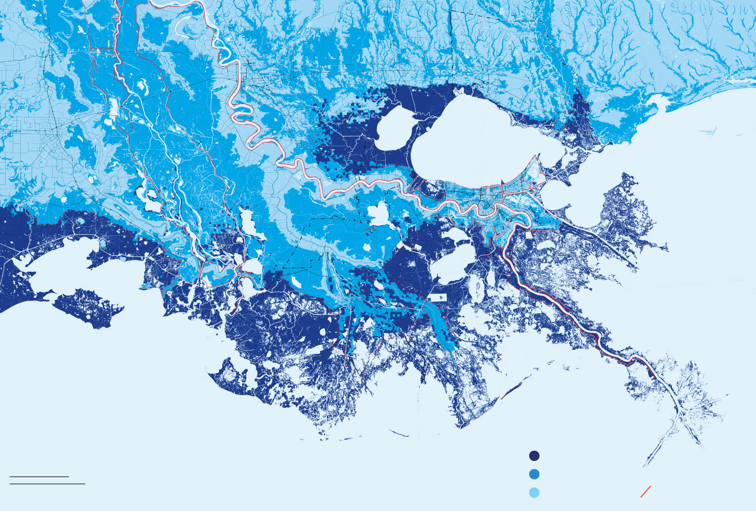
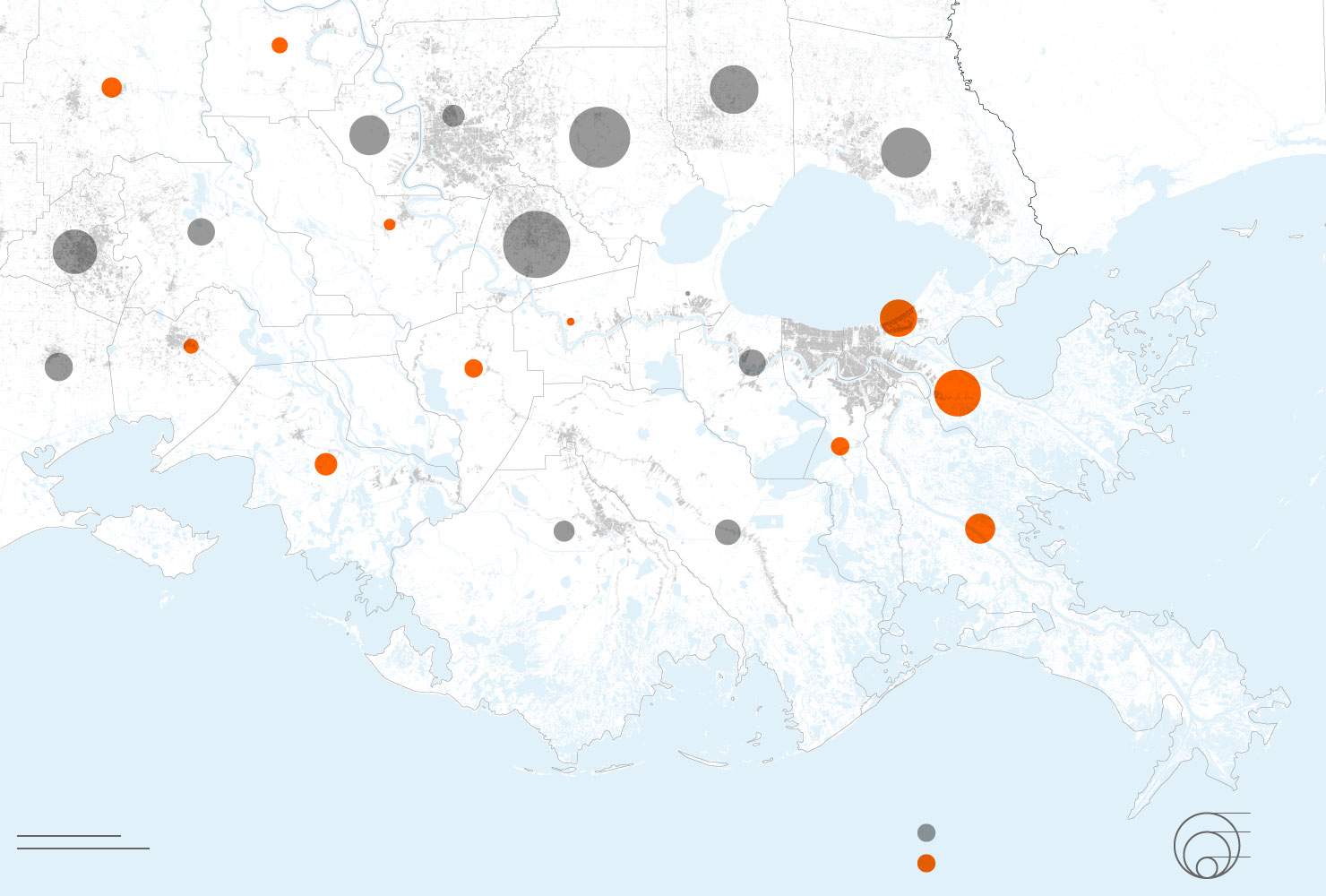
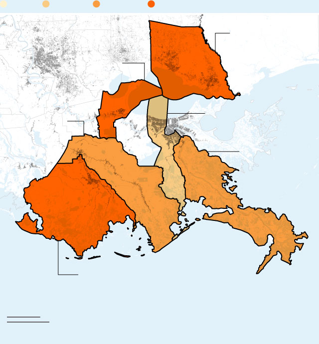
As waters rise, insurance is getting more expensive
< 50%
50–75%
75–100%
> 100%
Louisiana
Mississippi
+67%
LOUISIANA AVERAGE
+150–175%
ST. TAMMANY
+126%
ST. JOHN
THE BAPTIST
+74%
JEFFERSON
+97%
LAFOURCHE
+80%
PLAQUEMINES
+105%
TERREBONNE
20 miles
50 km
< 50%
50–75%
75–100%
> 100%
< 50%
50–75%
75–100%
> 100%
Louisiana
Mississippi
+67%
LOUISIANA AVERAGE
+150–175%
ST. TAMMANY
+126%
ST. JOHN
THE BAPTIST
+74%
JEFFERSON
+97%
LAFOURCHE
+80%
PLAQUEMINES
TERREBONNE
+105%
20 miles
50 km
< 50%
50–75%
75–100%
> 100%
Louisiana
Mississippi
+67%
LOUISIANA AVERAGE
+150–175%
ST. TAMMANY
+126%
ST. JOHN
THE BAPTIST
+97%
LAFOURCHE
+74%
JEFFERSON
+80%
PLAQUEMINES
+105%
TERREBONNE
20 miles
50 km
< 50%
50–75%
75–100%
> 100%
Louisiana
Mississippi
+67%
LOUISIANA AVERAGE
+150–175%
ST. TAMMANY
+126%
ST. JOHN
THE BAPTIST
+74%
JEFFERSON
+97%
LAFOURCHE
+80%
PLAQUEMINES
+105%
TERREBONNE
20 miles
50 km
< 50%
50–75%
75–100%
> 100%
LA
MS
+67%
LOUISIANA AVERAGE
+150–175%
ST. TAMMANY
+126%
ST. JOHN THE BAPTIST
+74%
JEFFERSON
+97%
LAFOURCHE
+80%
PLAQUEMINES
+105%
TERREBONNE
20 miles
50 km
In St. Tammany Parish, where Braud lives, almost 10 percent of urban land is in high-risk zones. That counts as lucky here: In Plaquemines Parish, the ever-narrowing strip of land that escorts the Mississippi River into the gulf, 55 percent of urban land is in high-risk areas—along with 41 percent of the population.
And those figures assume that Louisiana’s ambitious, $50 billion plan for preserving and restoring some of its coast, through such measures as diverting parts of the Mississippi, actually happens. If not, the risks will be even greater.
“Even a conservative projection does not present a rosy outlook for many of our most vulnerable communities,” Sanders said. “And that was really the point we were trying to illustrate.”
Sanders said that it would now be up to local officials to decide how much of the blueprint to implement. In his statement, Governor Edwards said his administration “will continue to do whatever we can to empower our citizens and local leaders.”
Photographer: Emily Kask / Bloomberg
Bloomberg News visited some of the communities identified as high risk before the report’s release. Those places ranged from remote fishing villages to recently developed suburbs a short drive from New Orleans. What each had in common was residents’ deep ambivalence about the idea of leaving.
Near Bayou Dularge, at the end of a long row of elevated homes in southern Terrebonne Parish, Danielle Verrett said it’s been years since the last big hurricane—which tells her it’s only a matter of time until the next one hits.
“Our number’s got to be pulled,” Verrett said. Still, asked whether she’d want to live somewhere safer, Verrett said she liked the wide-open space, as well as hunting deer nearby. “It’s kind of hard to move,” she said.
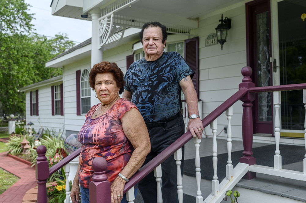
In the town of Lafitte, whose latest population estimate was 886 people, Melba and Westley Frickey live in a converted double-wide trailer with an immaculate garden, between a bayou and a lake. Melba rattled off the hurricanes—Rita, in 2005; Gustav, in 2008; Isaac, in 2012—that flooded their home. But the couple said they don’t want to move.
“I moved down here to go fishing,” Westley said. He said nobody from the government had ever talked to him about a buyout, and he wasn’t sure he’d take one if offered. Asked if he was worried about his safety during the next storm, he said only, “You never know.”
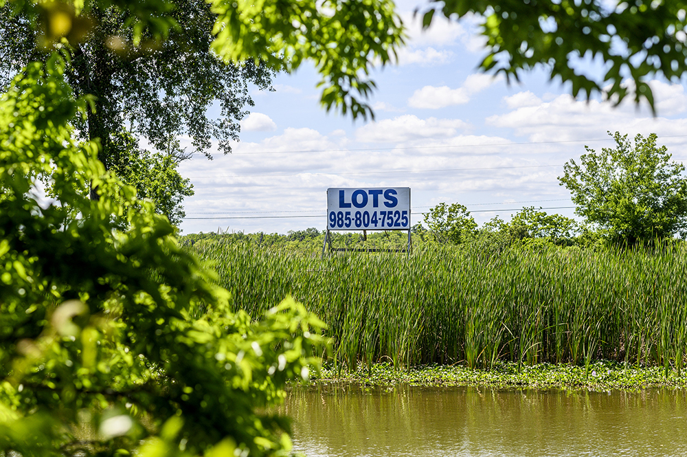
Photographer: Emily Kask / Bloomberg
Northeast of New Orleans, a neighborhood called Eden Isles offers homeowners easy access to the water, through a series of canals that look more like South Florida than the marshes of Louisiana. A sign at the entrance boasts “Waterfront Living At Its Best.”
Dave Robertson, who’s retired from the Navy, said his home here had only flooded once, when Hurricane Katrina put three and a half feet of water in his house and a refrigerator in his swimming pool. But his flood insurance has tripled since he moved here in 2004.
“I have not noticed any rise in waters through the years,” Robertson said. Still, “every hurricane season is anxiety.”
Braud, whose lakefront home is in the well-to-do city of Mandeville, said he wouldn’t take a buyout even if the state offered him one. “I don’t want my government pissing away money to buy my house,” he said. He argued that it makes more sense to raise the building even higher off the ground—something Braud doesn’t have the money to do himself.
And if the government really wants to reduce flood risk, he added, “stop building new structures in swamps or floodplains.”
In the meantime, until the water gets so high that it’s in his living room, Braud said he wants to stay. “The view is amazing,” he said. “I can enjoy the thrill of Mother Nature.”